project staleg : down to earth


imagine a time where birmingham’s development has reached its peak, where empty/unused spaces are now a rarity and the city is crying out for more space. buildings are getting higher and bitmingham has a near unrecognisable cityscape to that of 20 years ago. the “suits” as they have been referred are seeking to expand the city centre into its surrounding areas, meaning the complete transformation of some of birmingham’s most historically significant sites. this includes the area of digbeth.

but what about the people of digbeth, the current users. allowed for so long to inhabit this forgotten space, but destined to be pushed out through the use of compulsory purchase orders. 

solution : project staleg. 


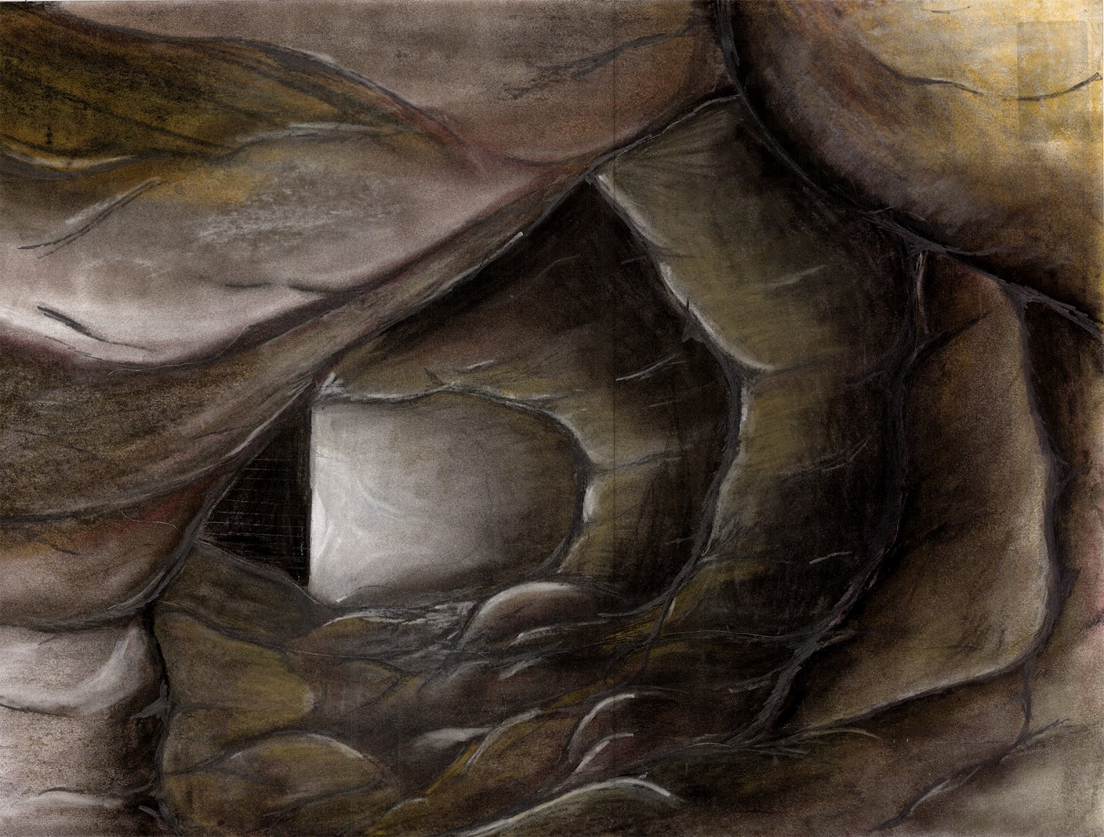
the consideration of time within the plan/section drawings is really interesting.. contours representing not topography, but the speed at which the diggers would be able to create their spaces.. how those would change relative to archaeological conditions encountered.

conceived as a result of a series of secret meetings between digbeths current occupants, project staleg seeks to create a new space, a space that could be forgotten once again, beneath the streets of digbeth. with an entrance hidden inside the walker building, a series of tunnels will be formed, expanding beneath ground as the space above is gentrified. a series of entwined staircases will be created from reclaimed materials thrown away by the contractors stripping out the surrounding buildings whilst structural elements are to be reused to prop up the vertical and horizontal tunnels.


the vision : a creative space that is truly public, growing almost like a root system to reveal an archaeological history. slowly, an underground world will evolve, a social system different to the one above will form. around the concept of self control, the people of digbeth will once again maintain their space.

these are long overdue. my apologies.

urban lighthouse

growing from a perception of crime in the area, this space reflects the light above down into the dirt and darkness of digbeth. allowing for a place of refuge, the design considers change, movement, and light in the landscape. adjustable tensile structures indicate a sanctuary within the changing world around it.


important to have drawing sets illustrating the structure and construction that relate to the experience of light and movement in the space.

interesting how the space changes tone and shading relative to the water level. how would the mirrors reflect? and the water? what are the lighting conditions in digbeth? overcast? sunny? night? how would the space differ? how would the water reflect differently?

how can you bring the project back to its origins within the representations and drawings? where is the grafitti? the crime? the light? please finish that model you have been talking about for so long now..


flickerings of light in the space. changing relative to water levels and radiating colors. how could these drawings become more experiential and communicative regarding your exact intentions for the space?

where is the graffiti, by the way?

its present, even on that exact site.


these last are the weakest of your images, simple views taken exactly from a model. each could|should be a drawing of its own, playing with light, graffiti, dirt and darkness. communicate the experience of the space you wish to provide.

beginnings of work

you are selling yourself short. these drawings are simply and ineffectively done. you can communicate in a more well articulated fashion, i have already seen it. think of the story that you are telling with your presentation : a set of design proposals along an untended railway. where are the proposals? how do they relate to one another spatially? programatically? where are the speculations as to how they will be constructed and how do they fit in with the existing context?

what are these details? what are they showing? why is nothing labeled? how does it fit into the project?
this is a drawing of an idea. ok, so how does it work? make yourself believe it through a drawing. make someone want to climb it. elevations. section details. how could these bricks be supported by fixings and the existing wall?


excavation

as digbeth is taken over and the graffiti is washed away from its surface, the area is redeveloped and its current inhabitants forced to leave, what kind of architectures could begin to exist beneath its surface?

also, this drawing, complete with speculations on construction, is really indicative of what youre thinking for this subversive architecture. really exciting explorations through excavations. space for new work to prosper as the explorers discover an archaeological past.

this section is really interesting, though could be more evocative and explanatory. scale? light? what is the space of the machines who dig versus the people who do? bring the people back into the architecture.

cannot wait to see where you take this project. really interesting and speculative.

there could be a duality between the sensuality of the images of color and the explanations of the line drawings. also, where is the graffiti you keep talking about? and the diggers? the people who reside there? can you build a model? bring back some of the carving techniques from last term?
great details showing time and process. i know this because youve told me. however, you need to explain this to any viewer. how can you communicate it within your portfolio?

drawing through an idea

curiosities about place. the rail line. the graffiti. the arches. the decay and the usage. where can research take a project. [also, this drawing needs to be labeled. no one knows what it means unless you tell them.]
anthropological histories, beneath the surface and above it. how does one design within that setting?
the drawing of ideas. what could be buried beneath the surface. a surface which is now being gentrified after a past of growth and industry. how would|could|should one explore it? what would those spaces be like? how would they expand through time?

contouring.

contour drawings can be fascinating as they are a way to illustrate the changing, physical world in a scientific way. this one is detailed because of its scale. this is actually covering a huge area, when you zoomed in, it wasnt as interesting. how do you develop your site with a similar level of detail?
the second drawing loses a lot of the clarity which was present in the map you found somewhere else. the precision is pretty important, especially when you are discussing the information about past|present|future rivers. is that condition of control precise or not so? consider that in your drawings.

the past|present|future of your site needs to be illustrated. change in topography. change in water level. is there a change in program and use through time as well?

the development of the site contours is actually quite interesting, especially when the two drawings are seen in the same manner and directly next to one another. you need a more exciting program to get this program off the ground. what would you like the site to be used for? really?

layers of information


in attempting to find relationships between different sets of data, the information can often become jumbled and difficult to understand. the labeling of the convoluted bits of drawing is increasingly necessary.

furthermore, how does one bring the beginnings of research into the design process, driving the assignment of space with curiosities and new discoveries?

graffiti.

interesting technique here. would be nice to be able to understand the layers of information in a more precise way. which are streets? which are canals? do the images relate to location? can this be annotated? convey the information.

why is it socially acceptable for street art to thrive in this area of the city alone? how could you investigate that architecturally? is there a relationship between shadow or points of view? major thoroughfares or lines of sight? how could you map this?

images versus maps

what are the differences between maps|drawings|images??

overlapping sets of information : places where knowledge in separate domains can be shown to overlap, leading to the possibility of intellectual travel.

points of convergence between those sets : linkages between information are identified and integrated. then the knowledge can be handled in new ways.

a map relates sets of information to one another, regardless of dealing with scale, color, time, event, experience. the colors being used amongst the decay of digbeth are interesting; however, they would become mappings if they were drawn through time. how do the light and shadows change throughout the day?

what if this image had a time lapse illustration of the movements in the shadows? maybe its only lines. maybe shade. maybe becoming color.


[un]mappable landscapes.

in a world of increasingly indistinguishable relationships between the technological and the human, mapping becomes a potential method to understand complex information. unlike the maps commonly used throughout history, the mappings of today do not merely represent the existing conditions. instead, mapping becomes a way to potentially re - describe a specific place, person, or experience with more particularity and significance. these maps attempt to recreate an experience or series of occurrences so that the observer can better understand the nature of the exploration.

installation|s and review|s.


installation|s : no matter how long you think it will take to construct a thing, it will be longer and require more particularity than you expect. it is easy to imagine the methods of construction, but without attempting such actions at full scale prior to installing, the imaginings will quite often fail.

the ideas behind this are strong. pulling the tones from inside, thinking of the window spatially instead of as just a surface. however, the actual interworkings of the materials were quite feeble. had this been properly detailed, it could have been extraordinary. the light on the line looks as raindrops do from a grey english sky.

what can you take forward from this process?


also, does anyone have decent photographs of how the line looked from outside? the elegance of the smashed window effect?

review|s : how far you guys have come from that first day wandering around the city is quite incredible. not only in your drawing skills and techniques, but more than that, in the way that you are thinking and the topics that you are considering. the comments at the reviews were constructive and encouraging. how can you take these ideas forward? light. shadow. decay. movement. color. life.

looking forward to working with you in the coming term.